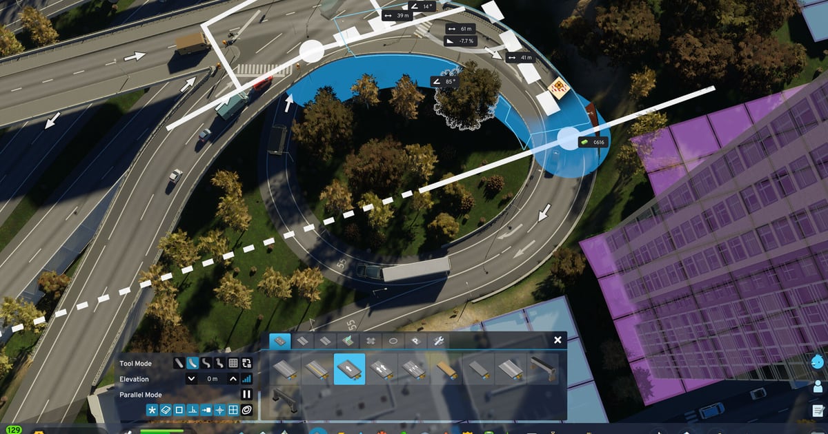
Traffic gridlock in Cities: Skylines II is not merely an aesthetic annoyance; it paralyzes city services, halts garbage collection, prevents ambulances from reaching patients, and bankrupts industrial export supply chains. The sequel features complex AI pathfinding where citizens weigh the time and money costs of every trip — road speeds, parking fees, and transit fares all feed into their decisions. Managing this requires strict implementation of real-world Road Hierarchy.
What this covers: Road Hierarchy tiers (Highway → Arterial → Collector → Local), Roundabout lane count mathematics, left-turn restrictions, and cargo bypass lanes. Why it matters: In CS2, vehicles change lanes dynamically, and worn roads slow traffic while raising accident risk, making intersection discipline vital. Who should pick this: Mayors watching red traffic heatmaps choke industrial zones and city center intersections.
The Four Tiers of Road Hierarchy
Never connect local residential streets directly to high-speed highways. Traffic must always transition through descending road classes:
| Road Class | Typical Width / Lanes | Speed Limit | Zoning Allowed | Primary Function |
|---|---|---|---|---|
| Highway (Freeway) | 3 to 5 Lanes Each Way | 100+ km/h | Strictly None | Long-distance inter-city transit and district throughput |
| Arterial Road | 4 to 6 Lanes (Divided) | 50 to 60 km/h | Yes (any zone type) | Moves high volume between distant urban sectors |
| Collector Road | 2 to 4 Lanes | 40 to 50 km/h | Yes (any zone type) | Gathers traffic from neighborhoods into arterials |
| Local Street | 2 Lanes (Narrow) | 30 km/h | Yes (any zone type) | Final destination access; lowest speed, quiet neighborhoods |
Connecting local alleys directly to an arterial creates traffic lights every 50 meters, killing average speeds and creating cascading highway backlogs.
Intersection Geometry and Left-Turn Bans
Left turns across multi-lane oncoming traffic are the number one cause of intersection gridlock. Cities: Skylines II includes granular intersection management tools:
- Ban Left Turns on Arterials: Use the Road Services tool to prohibit left turns at busy four-way junctions. Force drivers to use U-turn loops or grade-separated cloverleaf ramps.
- Remove Crosswalks at Bottlenecks: Pedestrians crossing four-lane roads will continuously stop turning vehicles. Delete pedestrian crossings at critical highway off-ramps and replace them with elevated pedestrian footbridges.
- Roundabout Sizing: A 4-lane arterial requires at least a Large Roundabout. Small roundabouts with two incoming multi-lane roads lock up immediately because vehicles enter before preceding cars exit.
Industrial Cargo Separation
Heavy industrial trucks behave differently from commuter sedans inside the traffic simulation. If industrial freight mixes with commuter traffic, your highway network will collapse:
- Build dedicated, grade-separated highway spurs connecting your manufacturing districts directly to external map borders and cargo train terminals.
- Never route cargo trucks through downtown collectors to reach rail freight stations.
The Four-Factor Pathfinding Model
The roads infoview is only half the story — the other half is how citizens decide where to drive. The CS2 wiki documents four route-selection inputs: Time, Comfort, Money and Behavior.
| Factor | Who Weighs It Most | What It Costs |
|---|---|---|
| Time | Adults | Travel speed; a longer highway can beat a shorter local road |
| Comfort | Seniors | Unnecessary turns, awkward merges, finding a parking spot or transit stop |
| Money | Teens | Fuel use and parking fees |
| Behavior | All agents | Willingness to make “dangerous” manoeuvres such as U-turns |
Emergency vehicles have a more permissive behaviour model and will make illegal U-turns when it shortens their route; ordinary vehicles switch lanes to let them through. Agents also re-route mid-journey to avoid accidents and stopped service vehicles, so a blocked lane can either clear itself or cascade depending on how much slack the network has.
Intersection Spacing and Lane Mathematics
Every intersection is a place where vehicles stop, so intersection density — not lane count — is usually what throttles a road. Community traffic guides converge on minimum spacing for each tier.
| Road Class | Minimum Spacing Between Intersections |
|---|---|
| Freeway | 500m |
| Arterial | 250m |
| Collector | 100m |
Two further rules govern the junction itself:
- Lane mathematics: the number of lanes entering a split should equal the number of destinations leaving it. A three-lane road that forks into two two-lane roads forces drivers to shuffle lanes at the last second.
- Acceleration and braking lanes: merge lanes let on-ramp traffic reach highway speed before joining, and separate off-ramp deceleration lanes stop vehicles braking in a live highway lane.
When a junction still locks up, the usual cause is a turning queue — a handful of left-turners blocking the whole line behind them. A dedicated turn lane at the intersection itself fixes it without widening the entire road.
Road Tools Worth Learning
Cities: Skylines II rebuilt the road tools around modes the first game did not have:
- Grid mode builds a full city block with three clicks — corner, width, then length.
- Parallel mode draws two roads at a fixed, adjustable distance, which is how smooth dual carriageway curves get built.
- Replace mode swaps a road’s type and adds or removes grass, trees, wider sidewalks and sound barriers without redrawing the segment.
- Cut-and-fill roads dig through terrain at negative elevation before the tool switches to tunnel, while stacked elevated roads let a highway ride above a parallel street.
Roads can also be upgraded in place with bus lanes and tram tracks, and dedicated bus-only and service-only roads can be built outright. Pedestrian streets prohibit every vehicle except service vehicles and delivery trucks, so they can carry local commerce without any through traffic at all.
Roundabouts and Premade Intersections
A roundabout is dropped onto an existing intersection rather than drawn by hand: pick a size, place it, and it adopts the lane configuration of the connecting roads. Four sizes exist, from small suburban layouts to large multi-lane rings, and vehicles inside follow roundabout rules. Small roundabouts on two multi-lane approaches lock up because entering traffic blocks the exits, so a four-lane arterial wants the large footprint.
Premade intersections live in the same menu: complex highway interchanges, plus transition pieces that join highways to regular roads and auto-connect to the existing network.
Parking Is a Traffic Tool, Not a Decoration
Parking availability feeds citizen pathfinding the same way transit stops do, which makes parking supply a congestion lever rather than an afterthought. Some citizens will drive anywhere for the closest spot; others will walk from a cheap lot on the fringe. The Roads infoview shows both parking availability and usage, so you can see whether a district is oversupplied with spaces or starved of them.
Roadside parking fees are adjustable between ₡0 and ₡50 per district. Raising the fee in a downtown area makes driving less attractive than transit; removing parking from dense cores and pushing it out toward train stations is the standard play. Do not stack a cluster of garages beside one another either — every car has to reach the same entrance, and the resulting queue can be worse than the parking shortage.
Road Maintenance and Accident Aftermath
Roads wear out. A Road Maintenance Depot dispatches vehicles to repair worn asphalt, and in winter snowploughs clear the network. The Roads infoview colours segments from green (good condition) to red (poor), and poor road quality or heavy snow slows traffic while raising the chance of a collision.
Accident probability is calculated per road segment and pushed up by road condition, lighting, weather and disasters. When one happens, a vehicle loses control, collision physics can chain-reaction through nearby traffic, and the affected lanes stay closed until police secure the scene and road maintenance clears the debris. Long closures push agents into their own re-routing and U-turn calculations — which is precisely when a redundant second route earns its cost.
Transit, Cargo, and How Lines Feed Pathfinding
Public transport is the highest-leverage traffic fix available, because every passenger is one fewer car on the network. Line economics are exposed directly: each line has a ticket price, a vehicle count and operating hours, and the ticket price feeds citizen pathfinding — a cheaper fare pulls riders off the road, a more expensive one pushes them back into cars. When a line runs near 100% usage, adding vehicles shortens waits at stops, which affects pathfinding again.
Cargo is its own layer. A Cargo Train Terminal acts as a distribution centre even before you create a cargo line — companies drop off and pick up resources there. Freight rail and ships then move the bulk of raw material, and cargo ships carry around 1,000 tonnes each. The catch is that terminals generate enormous truck traffic, so the road connections into a terminal must be oversized relative to the buildings around them. Keep those trucks off downtown collectors entirely and give manufacturing districts dedicated, grade-separated highway spurs.
Policies That Shape Traffic
District and city policies are traffic tools in disguise.
| Policy | Level | Traffic Effect |
|---|---|---|
| Heavy Traffic Ban | District | Keeps trucks out of residential streets |
| Speed Bumps | District | Slows traffic, cutting noise and accident risk |
| Gated Community | District | Blocks outsiders except delivery and service vehicles |
| Roadside Parking Fee | District | Charges for parking, pushing drivers to alternatives |
| Remove speed limits on highways | City | Faster flow, higher accident rate |
A Heavy Traffic Ban is the cleanest way to enforce the cargo-versus-commuter separation the road hierarchy is meant to create, and speed bumps are a cheap substitute for re-engineering a street that residents keep racing down.
Designing for Pedestrians Instead of Against Them
Pedestrian traffic is the most common hidden cause of a junction that looks like a road problem. Every pedestrian is a car that is not congesting the network, but a crowd crossing a four-lane road holds turning traffic through the entire green phase. The fix is not to widen the road — it is to remove the crosswalk and give people a footbridge, or to route the crowd away from the junction in the first place. Pedestrian paths and elevated footbridges permit steeper inclines than the smallest roads, cost nothing to walk, and let citizens bypass intersections entirely.
Offices make the point sharply: a single office building can employ hundreds of citizens, and if those workers all drive, no reasonable road can carry them. Public transport into office districts is the only workable design.
Reading the Traffic Infoview
The Traffic infoview overlays a green-to-red gradient by flow and can be switched to Traffic Volume in the map legend; clicking a road’s name pulls up details about it. Intercity traffic also appears in the simulation — freight moving from one Outside Connection to the next does not contribute to your economy, but it will route through your network if doing so is cheaper, so an accidental short cut can load an arterial with vehicles you never asked for.